More information on the Georgian period 1714 - 1837
In Dodderhill parish probably the most obvious change during this period would have been in agriculture. Methods of farming were improved in the ‘agricultural revolution’ and the way land was used may also have changed. Land was enclosed on a larger scale (although it seems this process had been going on, quietly, since the 1500s in the parish) so that the old huge open fields would have completely disappeared. Accurate surveys, plans and maps were produced for the first time showing estates with, in some cases, a lot of detail of the field names and sizes and their uses. Various ways were tried to improve the quality of the soil so that it became more productive. Fieldwalking has produced evidence of manuring with domestic midden material, often including sherds of broken pots, which seems to indicate an intense effort to boost soil fertility; and of burnt limestone slag being mixed in to the soil, and waste material being imported which seems to be from the salt-making areas of Droitwich. As the underlying soil is full of clay, farmers were probably trying to improve their fields a little. Pieces of large conical bowls with black-glazed inside surfaces show that dairy activities were increasingly being carried out, and this may accord with other evidence to show that much land was being put down to pasture (again, a more suitable use for clay soil).

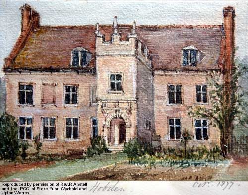
Hobden Hall, a watercolour of the Georgian house painted in 1877
Many of the farms such as Crutch Farm, Rashwood Farm, Impney Farm, Withy Furlong Farm and Colley Pits Farm were built or rebuilt during this time in brick, so the appearance of the parish would have changed from the earlier dominance of timber-frame constructions. Hobden Hall used a combination of stone and brick. Smaller cottages also seem to have been constructed from the early 19th century using bricks for walls and slate or tiles for roofs.
Roads were turnpiked from 1713, with the road from Chapel Bridge in Droitwich up to Bromsgrove, which passed through Dodderhill parish and Wychbold village, being turnpiked in 1749. This must have made a huge difference to local people and their ability to travel and to transport goods.
In the Vines area in the south of the parish, from 1768 the Droitwich Barge canal was constructed from near the Upwich Pit site (the Pit had gone out of use by then) using the old course of the River Salwarpe, which had a newer straight course dug out to the north, where it still flows today. The canal then ran parallel to the line of the Salwarpe out to the west and south to join the River Severn at Hawford. Opened in 1771, it was used to transport salt out from, and coal for fuel in to, the growing salt industry.
In 1815 the Worcester to Birmingham canal was constructed through the east side of the parish, and this too would have improved communications and transport by providing an easy link to the growing Birmingham area. Fieldwalking finds from near the canal include lots of fragments of clay pipes, discarded after the tobacco had been smoked, perhaps from the ‘navvies’ who built the canal.
In the early 19th century the first of the large salt-works was built in what is now Vines Park, on top of the by-then disused Upwich Pit, and no doubt inhabitants of Dodderhill parish were involved in work at this ‘factory’, the first of many to come. The northern part of Droitwich was still officially in Dodderhill parish, and maps show that cottages were built here to house the larger numbers of workers needed by the expanding industry. (Droitwich’s annual salt production by 1772 was 15,000 tons.)
The first of the national ten-yearly censuses was taken in 1801 and, although the earlier censuses record much less detail than those after 1851, they do give information about Dodderhill’s inhabitants.
The landed gentry had an influence on the local community, often owning large areas of the parish which were rented to the local inhabitants. Memorials to two of these land-owners, commemorated in local churches are illustrated below.
For more about the Vernon and Pakington families, click here
For more information about transport click here